History of terrain models
The first moulded terrain models were created for military purposes. Towns and fortifications were predominantly modelled, but also larger territories. Emperor Maximilian I. (1459–1540) for example initiated the manufacturing of four primitive terrain models of the eastern Alps during 1500–1540 by P. Dax [1] and Pope Clemens VII used a cork model of Florence created by Benvenuto di Lorenzo della Volpaia and Niccolò Tribolo to plan his siege of 1529/30 [2]. Venice became the first centre of relief modelling in the middle of the 16th century. Nearly 200 models were created to depict the possessions of the Venetian Doges in the Levant. [3] In Germany, Duke Albert V of Bavaria ordered Jakob Sandtner to fashion four town reliefs between 1568 and 1574. [4]
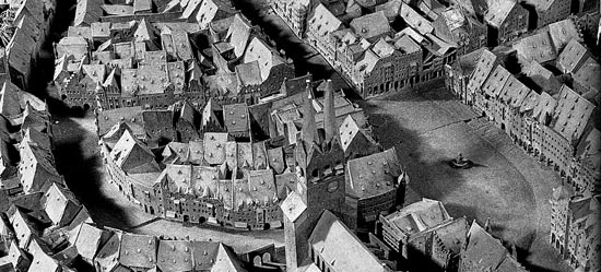
Bavarian National Museum
In Paris, Sébastian Vauban (1633–1707), the famous French fortification engineer of King Louis XIV, had outstanding accurate models be made of all his constructions and their environs [5]. He also created models of fortified cities of potential enemies and mountain regions. Both Paris and Venice in Italy were centres of terrain modelling [6]. These military models as well as topographic maps were not open to the public and of course were confidential.
For a long time, topographic maps were very rare and the problem of the representation of the third dimension was not easy to manage on maps. Especially in hilly and mountainous regions it was less difficult to create a three-dimensional model of the earth’s surface than to translate it into a two-dimensional map.
Whereas today a terrain model is usually shaped after the contour lines of a map, the approach at the end of the 18th century was reverse. The greater part of the “Atlas Suisse par Meyer et Weiss”, the most accurate map of Switzerland during the first half of the 19th century, was based on a terrain model of a great area of the Swiss Alps created by Joachim Eugen Müller (1752–1833). [7]
The art of terrain modelling in Switzerland reached a first peak towards the end of the 19th century. Prerequisites for this success were several new technical achievements like reliable contour maps of the whole country, the invention of photography, the upcoming alpinism and the strengthened scientific interest of geologists.
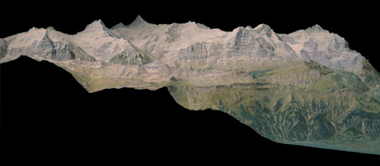
Swiss Alpine Museum
Between 1880 and 1940 Swiss relief modellers like Xaver Imfeld (1853–1909), Carl Meili (1871–1919) and Eduard Imhof (1895–1986) created a lot of impressive relief works.
Whereas large scale models benefitted from the use of photographs depicting even the smallest details, the production of small scale models was facilitated by the use of a pantograph. At the end of the 19th century, this method allowed milling out a model from a block of plaster, using the contour lines of a map to guide the milling cutter. Based on the pantograph, Karl Wenschow (1884–1947) developed a method to rapidly produce a large amount of accurate terrain models by pressing paper-moulds using the die stamping technique.
During World War II the Allies produced huge amounts of terrain models using different techniques. These models provided crucial information for the landing operations in North Africa and Normandy.
After World War II a procedure using vacuum formed plastic sheets had been developed in the USA to produce cheap reliefs in large quantities. Maps of the corresponding area where printed on the plastic sheets before their forming. This technique is still used today.
In the last few years, a new technology emerged, allowing the entire model to be generated directly by a computer-controlled 3D-printer. Different printing techniques producing uncoloured terrain models exist, which are all subsumed under the label Rapid Prototyping. A technique to paint the model after forming has also been developed.
[1] Gygax, Fritz. Das topographische Relief in der Schweiz. 1937. S.14 and Grün, W.-D.. Kretschmer, Ingrid. Relief. 1986.
[2] Stempien, David C.. Terrain models as battlefield visualization training tools. 2002. p.33. and Gottschewski, Adolf (ed.). Die Lebensbeschreibungen der berühmten Architekten, Bildhauer und Maler. Die italienischen Architekten und Bildhauer des 16. Jahrhunderts. Band VII. Strassburg 1910. S.229,230. a German translation of: Vasari, Giorgio. Delle vite de' più eccellenti pittori, scultori, e architettori. Firenze 1568.
[3] Gerola, Giuseppe. I Plastici di fortezze venete al museo storico navale di Venezia. In: Atti del reale istituto veneto di scienze. Lettere ed arti. 1930,31. p.217-221. cited after Roux, Antoine de. et al.. Les plans en relief des places du roy. 1989. p.22.
[4] http://www.bayerisches-nationalmuseum.de/Win/d/d.htm access 19.3.2006. and Reuther, Hans. Wesen und Wandel des Architekturmodells in Deutschland. In: Daidalos, II. Gütersloh 1987. cited after Roux, Antoine de. et al.. Les plans en relief des places du roy. 1989. p.22.
[5] Imhof, Eduard. Bildhauer der Berge. 1981. S.107.
[6] Grün, W.-D.. Kretschmer, Ingrid. Relief. 1986.
[7] See also Imhof, Eduard. Bildhauer der Berge. 1981. and Caminada, Paul. Pioniere der Alpentopographie. 2003.