Relief production during World War II [1]
“The terrain model, a briefing aid for the High Command as well as for the troops themselves, was most highly developed in the European theatre of World War II” wrote Harrison P. Reed 1946 [2].
|
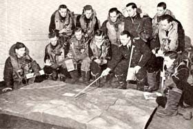
Briefing for a bombing raid using a model of the Alten Fjord in Norway 1:10,560,
Pictures from Chase p.106,107. |
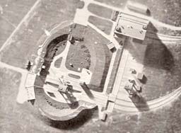
Model of the V2-rocket experimental station at Peenemünde (Germany)
|
During World War II both the Germans and the Allies produced a large amount of terrain models. In Germany, the Karl Wenschow Company at Munich produced reliefs using 24 pantographs and two presses. At the Institut Géographique National a Paris, four pantographs were used to produce models. During the German occupation, the French produced models of German territories for the Allied without being uncovered by the Germans.
In the USA and in Great Britain, the pantograph method was not in use. Instead, several techniques based on cardboard were prevalent.
The British began early to collect a comprehensive library of all kind of geographical information of Europe, like plans, aerial and terrestrial photographs, etc. These data were used since spring 1942 to create terrain models facilitating planning of major operations. It is during this time that the British experts introduced the Americans to the art of model making.
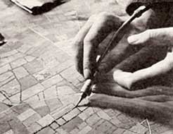
Applying hedges to a terrain model
using a compressed extrusion gun, Picture from Chase p.104. |
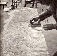
Finishing of a coastal model,
Picture from Reed p.643. |
The surface of the master model was covered with aerial photographs painted with transparent green oil colour. Buildings, hedgerows and trees are placed carefully and roads are painted with white colour, making the model appear very realistic. From this model, plaster moulds were made, serving as reproductions of the master model. These reproductions were made of PVC in different colours: buildings in white, trees in dark green, water in blue, etc. After applying these different coloured PVC items with a brush, the ground colour (light green) PVC could be applied over the whole model [3]. Other techniques were used for different models.
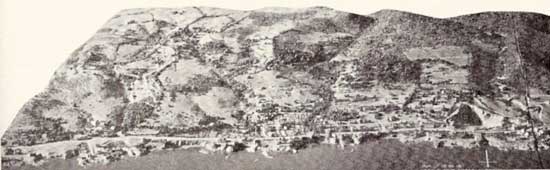
The models were first used for the planning of troop operations. Photographs taken from the points of view on the landscape the combatants would see in the field provided useful information in preparation of assaults and made the soldiers familiar to the situation they would meet. Even the conditions of illumination at the time the operation would happen were simulated.
In this manner, terrain models were used in a multitude of operations, like the assaults in North-Africa, Sicily and Southern Italy or the bombing of different targets like the oil refineries of Ploesti (Romania), the ball bearing plant of Schweinfurt, the Skoda works in Pilsen (Czechoslovakia), or the Möhne Dam and others. The complete reconstruction of the V2-experimental station of Peenemünde provided an instrument which helped evaluate the intentions of the Germans.
Picture from Reed p.635.
The assault models mostly had scales of 1:5,000 or 1:10,000, the bombing models were often in larger scales.
But the most extensive application of terrain models was the preparation of the invasion of Normandy. During 16 months, 398 different models were created. These models depicted the exact situation as it would be in the early morning of June 6, 1944. Thus, as the first landings were at low tide, the models had to show the width and gradients of the beaches correctly. Each alteration in nature caused by tidal erosion, new fortifications and underwater and beach obstacles placed during the several months the models were created had to be incorporated.
Reliefs also were helpful tools to choose the radar sites used to secure a forward moving front. For this purpose, a small lamp was placed on the relief while the cone of light indicated the field of view of the radar. When this lamp was positioned at a certain height above the relief, airborne radar could be simulated. In this manner, the coverage of a radio communication antenna also could be estimated [4].
[1] This article mainly bases on Reed, Harrison P.. The development of terrain model in the war. 1946. and Chase, Francis Jr.. These childish things. 1946.
[2] Reed, Harrison P.. The development of terrain model in the war. 1946. p.632.
[3] Reed, Harrison P.. The development of terrain model in the war. 1946. p.644-645.
[4] Kneissl, Max. Pillewizer, Wolf. Reliefherstellung. 1952. S.1.