Relief globes
Sonnenberg, school for visually handicapped children and adolescents, Baar
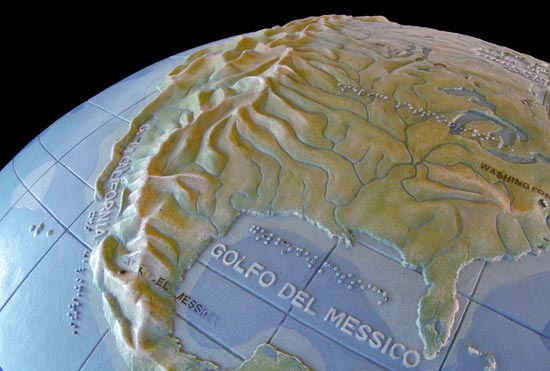
Globes are three-dimensional representations of the earth. But if you want to reproduce the globe realistically you should create a relief globe that also considers the terrain surface of the earth. At times vertical exaggeration is employed to make the relief globes more perceivable. Even Mt. Everest would be so tiny on a globe of a diameter of some decimetres that it is inevitable to exaggerate a relief globe. The larger the scale, the less the exaggeration can be. Most suitable is a carefully chosen graduated exaggeration, which emphasizes the flat regions like coastal areas and hilly landforms without distorting the high mountains too much [1]. Often, on relief globes both the landmasses and the sea floor are moulded.
The construction of a relief globe is rather complicated and different methods and materials have been adopted. The first relief globes in the world date to the 18th century. They were constructed in France in 1752 by Philippe Buache and in 1777 by his pupil Pierre Lartigue (1744 until ~1828). In Germany, Karl Wilhelm Kummer (1785–1855) made a relief globe in Berlin in 1820 [2]. After sometime, relief globes were created for the blind as well. The oldest wooden relief globe from the USA for example was made for this purpose in 1837 [3].
Not only the surface of the earth has been depicted in relief globes, but also other orbs were constructed as models. The first known relief globes were models of one half of the moon [4] and in the 1960s the moon landing expeditions were prepared using lunar relief models; whole globes [5] and sections were envisaged as landing places [6].
Until the first satellite launch in the 1950s, a relief globe was the only way to show the whole terrestrial globe at a glance and to depict the relations between the continents in their real proportions [7].
Today, a common production technique uses the method of thermoplastic relief moulding. Several segments (at least two hemispheres) are vacuum-formed separately and then merged together. Relief globe sizes range from a few centimetres diameter to several metres.
[1] Briesemeister, William A.. Some three-dimensional relief globes. 1957. p.258. Imhof, Eduard. Kartenverwandte Darstellungen der Erdoberfläche. 1963. S.92,93.
[2] Destombes, Marcel. Globes en relief du XVIIIe siècle. 1978.
[3] Briesemeister, William A.. Some three-dimensional relief globes. 1957. p.251.
[4] Destombes, Marcel. Globes en relief du XVIIIe siècle. 1978. p.225.
[5] Rand McNally and Company. It’s not green cheese. In: Ranally world. Vol.15. No.3. June 1963. cited after Ristow, Walter W.. Three-dimensional maps. 1964. p.23.
[6] Moon Crater Model. In: The military engineer. Vol.55. No.367. Washington D.C. 1963. p.363 and Aero Service Corporation. Models detail lunar landing targets. Scan (Philadelphia). vol.1. 1963. cited after Ristow, Walter W.. Three-dimensional maps. 1964. p.1.
[7] Wilson, Jack. The world in space. 1957.