Swiss reliefs
In Switzerland, the art of landscape modelling had a long tradition and reached its first peak during the end of 19th century, and there are various reasons for this. One reason for this could be that the mountainous landscape made it difficult to represent it on maps. On a flat map the vertical dimension can never be shown as clear as with a relief. But this challenging landscape provoked Swiss cartographers, and soon in the 19th century, Swiss maps were considered as the best maps in the world. The Swiss cartographers benefitted from the great French tradition in cartography in the process, as several Swiss were engaged in the French army. Moreover, the young Swiss nation, founded in 1848, consisted of different ethnic groups, belonging to different religious denominations and speaking four distinctive languages. Thus it was important to create a national feeling. To hit this target, maps and reliefs were perfect means. They displayed the landscape and its structure as well as the boundaries of the nation. So they functioned as a bracket keeping the nation together. Thus, reliefs and maps were popular with both the state and the public. [1]
The oldest preserved terrain model of the Swiss Alps was created by Franz Ludwig Pyffer von Wyher (1716–1802), a lieutenant general in France, who returned back to his birthplace in Switzerland after his retirement from the French army. For 24 years, he shaped a part of the central Swiss Alps around Lucerne and set the starting point for a long and successful terrain modelling tradition in Switzerland. In contrast to previous models his model was not designed for military purposes, but emerged only out of topographic interest [2].
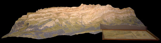
Relief of a part of the Bernese Oberland and the Valais 1:108,000,
Swiss Alpine Museum |
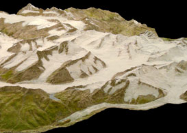
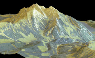
Relief of the Aletsch Glacier and its surroundings 1:50,000,
Eduard Beck was one of the first modellers to use contour maps as a template. Swiss Alpine Museum |
Whereas today a terrain model is usually shaped after the contour lines of a map, the approach at the end of the 18th century was reverse. The rich fabricant Johann Rudolf Meyer (1739–1813) decided to map the whole area of Switzerland. For this purpose he engaged the Alsatian geometrician Jean Henri Weiss (1758–1826) and Joachim Eugen Müller (1752–1833), a carpenter of the alpine village of Engelberg. The latter created a stunning terrain model of a great part of the Swiss Alps which served to create the best part of the “Atlas Suisse par Meyer et Weiss”, the best map of Switzerland during the first half of the 19th century [3].
The art of terrain modelling in Switzerland reached its first peak during the end of 19th century. Prerequisites for this evolution were several new technical achievements like reliable maps of the whole country such as the Dufour map, first sheets of the “Siegfriedatlas” and a series of surpassing maps edited by the Swiss Alpine Club SAC, further the invention of photography, the upcoming alpinism and the strengthened scientific interest of geologists.
One important promoter of terrain modelling was Albert Heim (1849–1837) professor of geology at the ETH and the University of Zurich. For example, he created plaster reliefs displaying geomorphologically typical landscapes for use in schools, but what proved most relevant was his encouragement to young students to create models. Under his influence, a lot of impressive relief works were created between 1880 and 1930.
One of these students was Xaver Imfeld (1853–1909), according to Imhof, professor of cartography at the ETH Zurich, the world’s best modeller ever [4]. For example, Imfeld created a brilliant model of the famous mountain Matterhorn in the large scale of 1:5,000. His masterpiece was a relief of the Jungfrau group in 1:2,500 which was a showpiece for the Jungfrau railway at the World Exhibition of 1900 in Paris.
Due to a large amount of photographs, these models could be modelled in a much more realistic manner than ancient ones. Especially for nearly vertical rock faces, a map cannot provide sufficient information for a large scale relief. Outlines of the terrain are indispensable of course, but photographs contain much more details, and it is not necessary to depict all the details in the field.
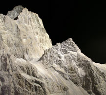
Pilatus, Glacier Garden Lucerne |
However, for small scale models it may be sufficient to generate a model only based on the contour lines of a map. For this reason, the pantograph was invented at the end of the 19th century to create terrain models efficiently. This method allowed milling out a model from a block of plaster while using the contour lines of a map to guide the milling cutter. Using this method, Charles Eugène Perron (1837–1919) created a plaster relief of the whole of Switzerland in 1:100,000.
In Switzerland, the art of plaster terrain models reached a last peak with Eduard Imhof (1895–1986), who created two splendid large scale models of the mountains Bietschhorn and Grosse Windgälle for the Swiss national exhibition 1939 in Zurich [5].
[1] See about this topic Speich, Daniel. Papierwelten. Eine historische Vermessung der Kartographie im Kanton Zürich des späten 18. und des 19. Jahrhunderts. Zürich 1997.
[2] See also Imhof, Eduard. Bildhauer der Berge. 1981; Caminada, Paul. Pioniere der Alpentopographie. 2003; Niederöst, Jana. Das Relief der Urschweiz von Franz Ludwig Pfyffer. 2002.
[3] See also Imhof, Eduard. Bildhauer der Berge. 1981; Caminada, Paul. Pioniere der Alpentopographie. 2003.
[4] Imhof, Eduard. Entwicklung und Bau topographischer Reliefs. 1939. S.288.
[5] Imhof, Eduard. Bildhauer der Berge. 1981. S.137-143.